Hiking The Long Range Traverse, Gros Morne, NL
Posted on Sep 18, 2011
The Lead Up
We set out from St. John's on a beautiful September afternoon. We're heading west on the Trans Canada Highway at a steady 110km/h in our recently-repaired Mazda Protege, which is packed full of camping gear and food. Our destination is Gros Morne National Park, where we plan to hike the 5 day trek across the Long Range Traverse. Nicole is in the passenger seat as usual, and our good friend Shawn Meredyk is in the seat behind her. He's playing DJ using his MP3 player and an FM transmitter. The rest of the back seat is a slew of camping gear and last minute items that refused to fit in the trunk. We are excited, and it seems like we chat about random science and recent events for only a few minutes before we are rolling into Clarenville looking for a breakfast/lunch. After a brief and unintentional tour of the town, we decide the best option for lunch is McDonald's. Although none of us has eaten McDonald's for years, there are only a few options and we're in a hurry. Luckily, the 1/3 Pounder Angus Bacon Cheese Burger is surprisingly good, and I don't even feel sick after eating it as per my previous McDonald's experiences. Our excitement carries us through another few hundred kilometers before we decide to make another brief stop in Grand Falls/Winsor to refuel. I also take the opportunity to stop at Gee-Eff-Dubb's Canadian Tire, to replace the hunting knife I had unfortunately lost on our recent trip to the Burin Peninsula. It's around 8:30 PM and it's just getting genuinely dark by the time when we roll up to the Berry Hill campsite in Gros Morne National Park. We've just procured a load of firewood from the Irving in Rocky Harbour which is awkwardly sitting on Shawn's lap since there's nowhere else to put it. We're driving at about 15km/h up the short and windy road to Berry Hill, when suddenly Nicole reports that she sees a moose ahead! Sure enough, a young cow trots out of the trees. We watch her trot along in front of the car for a ways, before finding a trail to trot off to. In retrospect, I should have seen this early moose sighting as a sign of things to come. Instead of scrambling to take (unsuccessful) night photos of the moose, I should have let nature's warning pass with more reflection on our plans and circumstances. We set up camp and begin to prepare dinner. Matt Johnston and Natlie Szponar arrive about an hour after us, also laden with camping gear and food. We are glad to have our complete group there, all across the island successfully. A few beers, burgers and laughs, and I fall asleep by the fire. It takes a little longer to do the final morning pack up of our bags than we'd anticipated and we are acutely aware that the boat tour we have reserved spots on will leave at 1 PM, with or without us. Despite our time contraints, we consider it time well spent listening to the advice of the park staff member who shows up in the morning to collect our $25 camping fee (well worth it for the super nice shower facilities). He tells us that two men from Toronto needed to be rescued last week on the traverse. They had become lost and were found by helicopter after being reported as two days late (and missing their flights home) by their parents. Apparently, they had wandered about 2km off course on their second day and became completely lost. Unable to find their way back, they set up camp and waited to be rescued. In addition to this woeful story of two misguided main-landers, he also shared a few details and recommendations about the trail that proved to be good complements to our topo maps and GPS setup. We finally head off with eagerness and little time to spare to the visitor's centre near Rocky Harbour to obtain our permit and pick up our VHF telemetry unit. Our time-restraint becomes even more dire when we discover that what we had been told would be a casual compass skills/preparedness shakedown by the park warden is actually a three page written test on compass and map navigation skills. Most of the questions were quite easy, and designed to make sure we're aware of the appropriate declination settings. But of course, with all 5 of us having Bachelor-or-better degrees in science, we made our answer to one of the questions more complicated than they needed to be. The question asked "You walk 1.5km at 80 degrees west and then 500 m at 170 degrees. Plot a course back to your starting point." Given the wording of the question, I don't think it was unreasonable for us to whip out a calculator and calculate the straight line return tangent vector, however what she was looking for was just for us to tell her the bearings we'd use to retrace our steps, which is of course, much easier. Day One: Western Brook Pond After finally finishing the test and obtaining our permits we high-tail up to Western Brook Pond, and pound off the 2km walk to the start of the boat tour in minutes. We pay for our boat tickets and wait for the tour to begin, taking advantage of our last chance to enjoy running water for a while. 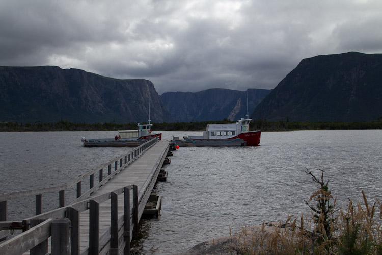 Everyone else on the boat takes notice of our large packs, and we're fielding lots of questions about the trip we are about to undertake. I don't think we were paying as much attention to the tour as everyone else. Instead our mood was of relief at having finally finished the tedious organizational part of the trip. All that was left to do now was to walk the distance. 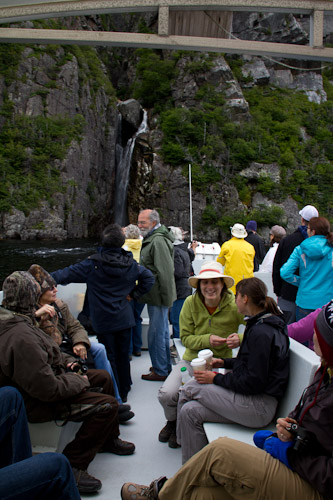 I crammed into the front of the boat with some 20 other tour passengers to snap this photo of the end of Western Brook Pond. In the trees at the very end of the pond is where we will spend our first night.  After we unload our gear onto the tiny dock, the noisy boat pulls away and a deep quiet sets in. Shawn breaks the silence before it becomes unnerving. "Woo!" he shouts out. "Shit just got real, son!" After all our planning and organization, things did feel real now, especially with such enormous cliffs looming all around us. Most groups undertaking the traverse in summer will summit on the first day, but in September, the boat only runs once a day, and by the time we get off the boat it is almost 2:30 PM, so it's impractical for us to start the ascent that day. We've been informed that it's at least a 6 hour hike to the first campsite, and it gets dark around 7:30 PM at this time of year - earlier in the gorge. Instead we enjoy the box of wine we brought, and cook a few sausages on the fire. Day Two: The Ascent We wake up fairly early in the morning to find that, with the wind having died down considerably overnight, our campsite has become a black fly haven. We load up as quickly as we can and get moving. We're all fresh and it's not long before we enter a beautiful meadow of shoulder high flowers. 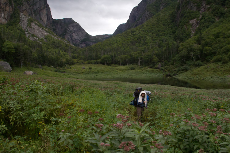 The ascent is difficult at parts, largely due to its steepness. At one part, a tricky rock face forces us to take off our packs and pass them up. Navigation, however, is not as difficult as we had imagined. The path seems fairly well trodden here, and with tall cliffs on either side, it is impossible to get too far off track. For most of the way, we simply follow a dry river bed, not bothering with many of the small trails that criss-cross it. After a few hours, we reach the waterfall we had been instructed to locate. The steepest part of the ascent route follows to its right and is reportedly the only passable way up to the top. 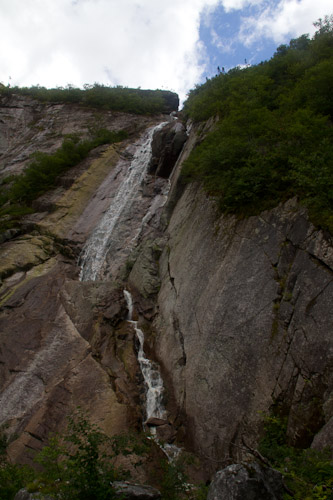 After another hour of climbing straight up, we pass above the tree line and stop for a break. It's windy, and that provides relief from the bugs, but with sweaty backs it is easy to catch a chill and we don't linger for too long. We pause just long enough for me to deploy my gorilla pod on a rock and snap this photo of the five of us. 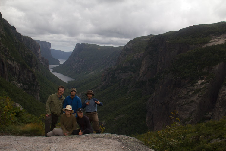 The terrain is so different when we reach the top. For the most part it is wide open, and much more windy. We easily polish off the last ~1km to the first campsite at Little Island Pond and briefly consider a push on to the next camp site at Mark's Pond. Daylight is fading, and having just hiked up a very steep hill, we decide it makes the most sense to stay the night. While we're pumping water and making dinner, we notice two moose grazing across the lake. The fact that a male and female are so close together indicates that the moose have definitely entered the rutt. I fully expect the moose to tromp through our camp site that night; there are tracks and scat everywhere. 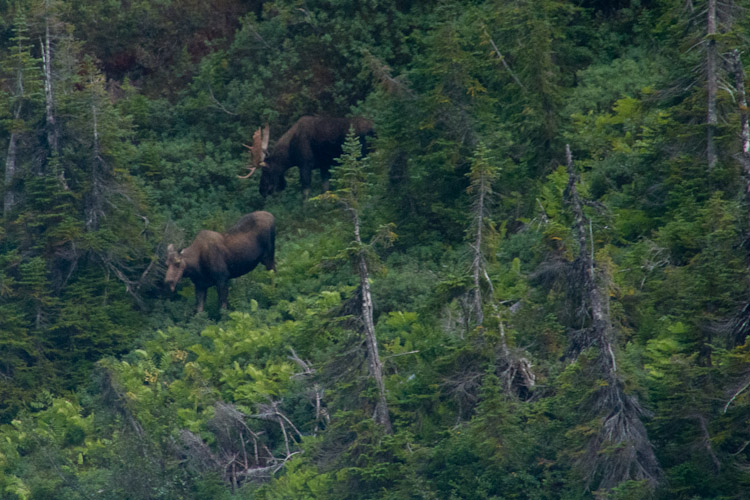 It's not until around 2 AM that we find out just how close our encounter with the moose will be. At first, I'm awoken by the cow splashing in the lake a few meters from our tent. I wake up Nicole and pop my head out of the tent to have a look. She is aware we're there, looking right at me while she chews on a few tasty weeds. She seems to be just passing through. A few minutes later, the cow hasn't moved, but we begin to hear the loud grunting of the bull, about 20 meters up the hill. He's close, and he's moving toward the female. Suddenly, he begins to ram small trees with his antlers and his grunting intensifies - I suspect he has detects our scent. We decide that being in between the male and his lady is a bad place to be, and it's probably time for us to make some noise before the male gets any closer. I start shouting and clapping my hands. Shawn, who's awake now and in his tent just up the hill from us, blows his rather loud fox 40 whistle. That causes the male to spook and he runs back up the hill 10 or 15 meters. The female, who had previously been unimpressed with any noise we were making, also becomes agitated and trots out of the water and right up to our tent. She pees a few litres, and somehow avoids tripping on our tent fly cords. She then realizes how close she is to us and really spooks, busting through the trees in the direction of Shawn's tent. In her panic, she trips on one of the cords holding Shawn's tent down, and takes a chunk out of the tent platform's 2x10 with her hoof in the process - all less than a meter from where Shawn is hiding out in his tent! The pair revisit our campsite twice over night, but each time we're able to make noise and keep them at a more comfortable distance. Day Three: A Slog in the Bog Our goal for day three is Hardings Pond, and despite having a sleepless night filled with moose encounters, we're out of camp fairly early and on our way. The weather is overcast and drizzling at times. The trail is relatively flat, and our biggest obstacles are slips and splashes in the boggy sections. I'm glad that everyone has appropriate rain gear and decent boots. We spot a vacant ranger station over the hill that tells us we have arrived at Hardings Pond. We arrive to discover that one of the tent platforms has been destroyed, undoubtedly ripped apart for firewood. The campsite is also very exposed, and the wind has picked up quite a bit. The wind is so strong in fact that it breaks one of Matt & Natalie's tent poles while they're setting it up. After a repair, we decide to relocate them down to where Shawn has set up his tent, on a small section of sandy beach that has better cover from the wind. The night is cold, with a strong wind and a few sprinkles of rain, most notably while we are preparing dinner. Later in the night, the wind dies down and we can hear owls and loons calling in the night as we drift off to sleep. Once again we're woken up abruptly by a moose visiting us. This time Shawn hears it first and makes some noise before it gets too close. I peek my head out of the tent just long enough to see the bull's large rack glint in the moonlight as he trots past our tent some 20m away. Luckily, he does not return and we are able to get some solid sleep. Day Four: Blue Skies and Tuckamore When we wake up, Hardings Pond seems like a completely different place. The sun is shining, the air is still, and the skies are completely blue. Luckily, it's still cold enough that we're not bothered much by the black flies until we're nearly done packing. 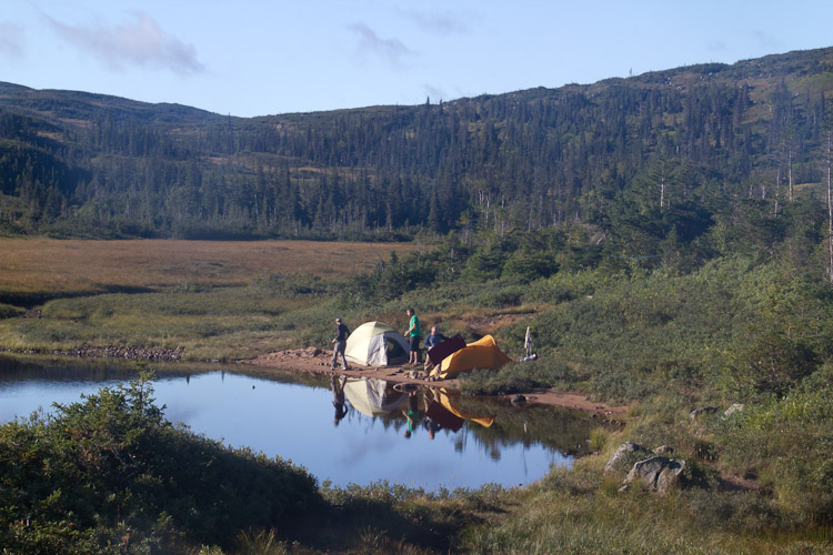 We knock off the first few kilometers of the day with ease, making good progress toward Green Island Pond. Our progress slows considerably when we encounter large sections of tuckamore. We plot smart paths around it wherever possible, and send ahead a scout to check the passability of moose trails through the unavoidable sections. We make it through eventually, but there is no doubt that it has slowed our progress considerably. After crossing between two lakes, we climb for nearly an hour to the top of a large ridge and take a moment to look back over the terrain we have just passed through. 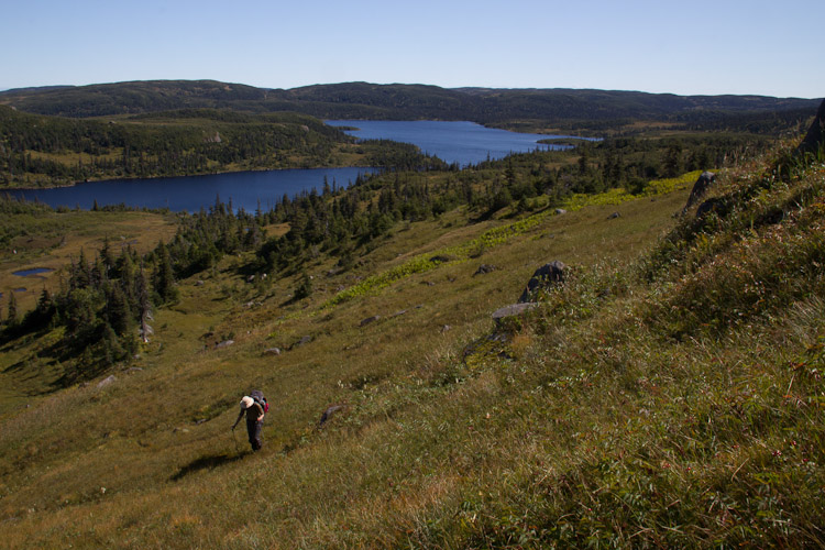 On the far side of the ridge, and drawing closer to Green Island Pond, we are treated to a view stretching all the way to the ocean. We can see Gros Morne in the distance, and although we're not ready to leave yet, we're happy to have our exit point finally in view. The view cheers us up, a timely reminder of why we're doing this after a tiring climb and several frustrating sections of tuckamore. We set up the tripod again and snap this fun photo, that I'm instantly sure will make a great memory for years to come. Gros Morne is visible in the center left. 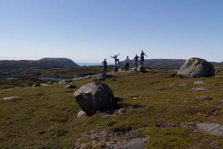 The camp site at Green Island Pond is beautiful, and best of all, we were not woken up at all by moose tromping through in the night. 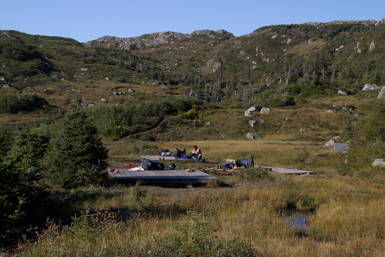 Day 5: Down, Down, Down Dark clouds rolling in quickly when we awake, but are courteous enough to hold off until we're finished packing up. We all remark that if a typical Newfoundland RDF day (rain, drizzle, fog) is going to happen, we're glad it's the last day. A slight navigational error at the beginning of the day costs us around 30 minutes and a lot of wasted effort. We feel silly when we realize that the best place to cross the river is actually directly across from the Green Island Pond, and not farther down stream as our interpretation of the map had suggested. Nonetheless, we're making good progress along a well travelled path, until we walk over a small ridge and spook a large Bull. He runs a short distance away from us and up a hill. He stops there and waits. Unfortunately, he has stopped directly where we need to go, and we don't have many options for going around, given that there is a large cliff dropping off 30-40m to our right, and a large lake directly to our left. 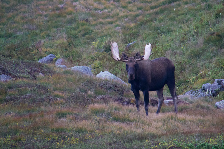 Waiting him out proves hopeless. He seems content to munch on trees and stare at us all day. Eventually, he moves slightly further up the hill along the trail - enough that we feel we can get around him on the right without getting too close to either him, or the unpassably steep terrain further to the right. Everything seems fine, and we are about 30-40m to the right of the moose when he starts ramming trees with his antlers and becoming generally agitated. We quicken our pace, but it seems he's even more startled by the fact that we're now climbing higher up the ridge above him. The moose snorts and sets into a terrifying bluff charge of nearly half the distance between us. Everyone breaks into a sprint up the hill and the moose gives up, satisified that he has asserted his territorial dominance. A dense fog accompanied by heavy rain and wind sets in shortly after our moose encounter, and we put our heads down and hammer over the remaining ridges. When we finally reach Ferry Gulch and start the descent, we're surprised at the reputation it has earned. We had been warned that Ferry Gulch was one of the more difficult sections of the trail, and while some sections were slippery, especially in the wet weather, none of us consider it more difficult than the first day. The trail meets up with the Gros Morne trail at the Ferry Gulch campsite, and although the last 6km seems long, we enjoy that we can set aside the GPS and maps and simply follow the trail. When we finally arrive home, I load up the GPS track we logged during our trip and convert it into a google earth kmz file, which you can view below. If you're undertaking the trip, I'd advise against following our route exactly. While we didn't wander too far off route, some parts of the track below are less direct than they could have been. Some of these divergences from the ideal path were just us exploring around, but at one section we were forced to leave a fairly well beaten path to avoid an angry moose. The complete gallery of photos from our trek is available here. blog comments powered by Disqus |

|