The Spout Path, Petty Harbour to Bay Bulls, East Coast Trail, NL
Posted on Jul 17, 2011
The Spout Trail is one of the most beautiful sections of the East Coast Trail, and probably the most challenging as well. It is named for its most interesting feature, a wave driven geyser that shoots a misty spray several meters into the air at regular intervals.
Our first experience on this trail was over a year ago, in early May 2010, when we walked 21km from Shoal Bay Road to Bay Bulls in one day. It was a long and soggy day, but only carrying a light day pack definitely made some sections of the trail easier. This year, Nicole and I decided to revisit The Spout Path, but this time we would combine it with Motion Path for a ~35km multi-day trip, over 3 days and 2 nights. The following is our travel log from that trip. 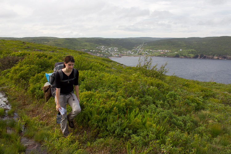 We leave a little early from work on Friday, with the car already packed, and head straight to Petty Harbour. Despite a weather forecast promising light rain, it is actually sunny with a pleasant light breeze. We're determined to make as much progress along the trail as possible before it gets dark, and we knock off the first big uphill out of Petty Harbour with relative ease and optimism. After the first big hill, the terrain opens up and the first few km's are reasonably flat, although definitely soggy in areas. Pitcher plants line the path, full of oozy liquid, waiting to soak up any unfortunate insects. 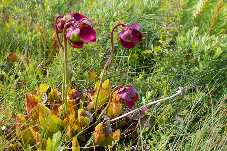 Somewhere between km's 4 and 5 we encounter our first major obstacle - a difficult river crossing. It seems like the river is normally cross-able via a couple of large boulders which lay in the stream, but at the moment the stepping stones are under a couple feet of raging river. The pace of the water is such that I'm not confident I could even stand in the water, let alone cross it with a heavy pack and stay dry. Fortunately, we locate the remnants of a beaver dam a short distance upstream and we use it to cross the river without getting too wet. The delay, however, means that we're behind pace, and daylight is running out. Our goal of reaching the Miner's Point campsite by nightfall may be too ambitious. As we trudge on, a dense fog begins to roll in from the ocean, bringing a light drizzle with it. With daylight fading, we contemplate setting up camp, but there are few suitable spots. We throw on our head lamps and walk the last two slippery kilometers to the Miner's Point campsite in the dark. Miner's Point doesn't have tent platforms like most East Coast Trail campsites, so we search around in the dark for a while, looking for the best place to set up. Luckily for us, the heavy rain holds out just long enough for us to set up our tent, and we cook dinner in the vestibule just as the rain and wind are picking up. We're glad we pressed on to the relatively sheltered area around Miner's Point campsite - this storm would seem much worse out along the exposed coastline. It proceeds to rain another 40mm over the night (according to Environment Canada), but we stay completely dry, thanks to our MEC Wanderer 2 tent and the shelter provided by the trees. In the morning, I walk down to the nearby stream to get water for breakfast and realize just how lucky we are to have chosen a campsite at a higher elevation - The nearby stream busted a bank overnight and now the two designated camping spots closest to the stream and trail are under a few inches of water. 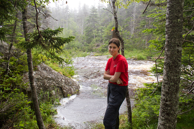 The second day starts with two more difficult water crossings, forcing us to finally accept that we are destined to walk this trail with wet feet. The good news is that the extra rain overnight makes extra water for the numerous waterfalls along the trail. One of the most scenic areas along the trail is at Queen's River, just south of Shoal Bay Road. When we arrive there and stop for lunch, the sun finally starts to cut through the fog, and I slip on my ND Fader to take these pictures. 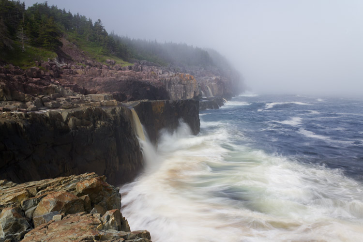 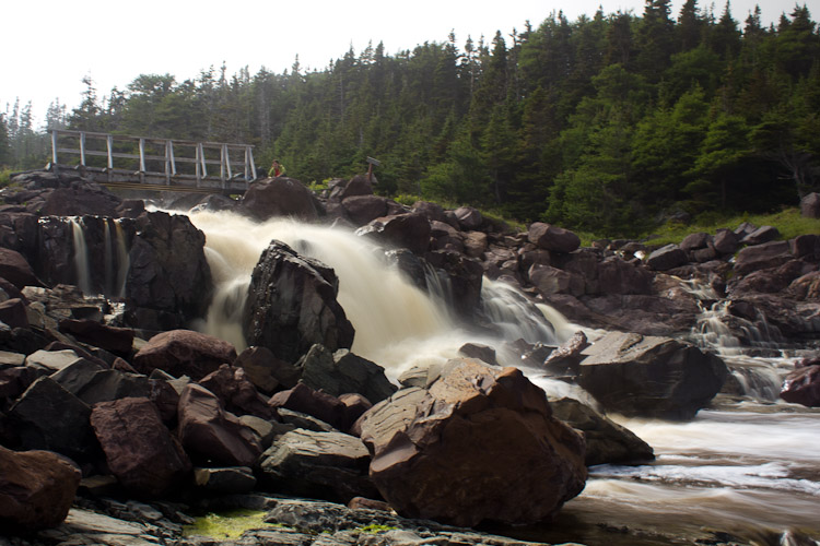 Approximately 2 km past Queen's River, we encounter three hikers - the first we've seen on the trail. They tell us how they had intended to walk from Shoal Bay Road to Bay Bulls in a day trip (as we had done last year), but when they reached The Spout River, they had been forced to turn back because the river couldn't be crossed. After wishing them luck and thanking them for the information, we decide to walk the additional 2km to The Spout despite their warning. Even if the river is not cross-able, we can camp the night there, and bail out the next day. When we finally reach it, we see what they mean. The river is gushing a lot more water into the ocean than it was when we were here a year ago. We notice, however, that the river widens considerably at its mouth, and it turns out to be an easier crossing than some of the rivers we have already encountered. 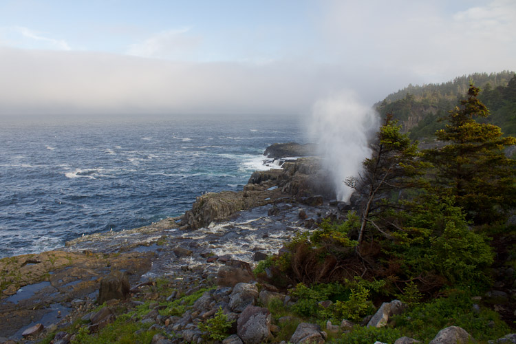 The extra water combining with high tide makes for a very dramatic effect from the spout. In fact, it is spewing so much spray into the air with each eruption that I only manage to get one clear photo before my lens is peppered with spray. 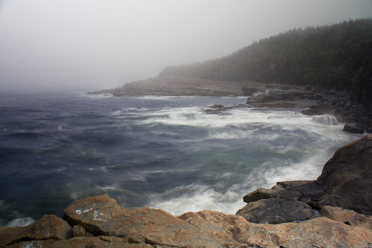 Just a short leg after the spout we arrive at Little Bald Head and set up our tent on one of the platforms. Our second night goes without incident, and a light sprinkle in the night is barely noticeable after our first night. 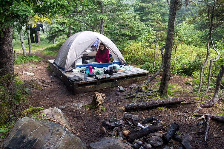 The trail on the third day leads us along some very high cliffs. Towering sea-stacks and beautiful waterfalls line the coast, and we can see whales splashing just off the coast. We even catch distant glimpses of puffins, who are no doubt visiting for a meal from the nearby Witless Bay Ecological Reserve. 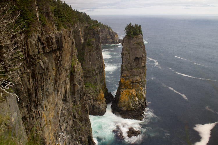 A bald eagle is hanging out on the top of one of the more impressive sea-stacks. His presence is making the seagulls who live there quite uncomfortable, and eventually they organize into a squadron and commence attack dives until the eagle finally responds.  The eagle screeches, soaring around the sea-stack. He is undoubtedly looking for an unguarded nest. While we are watching the bird-drama unfold, Nicole uses our point & shoot to take a photo of me playing photographer. Fortunately, I was able to crop out my plumber butt. 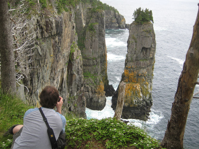 The coast along the section between The Spout and Bay Bulls is particularly beautiful. Waterfalls and high cliffs continue to make for great photography opportunities all the way until we reach the lighthouse. 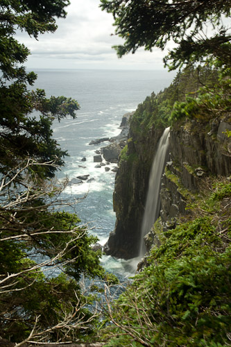 The final day of the walk proves to be the longest yet. It is hilly, and the path is severely washed out in places. We pause several times to rest and enjoy the scenary, and we're happy when we finally spot the lighthouse that marks our entrance into Bay Bulls. 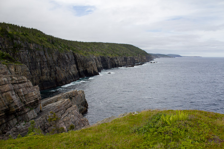 The section between Bay Bulls and The Spout is definitely the most scenic of this hike - I would encourage anyone who is doing an out-and-back trip on this trail to start from Bay Bulls. It's a pretty long walk to the Spout, but the scenary is definitely beautiful. 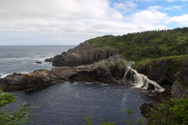
blog comments powered by Disqus |

|